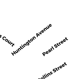
38 PEARL ST
Owner Information
SIELICKI JOSEPH M
38 PEARL ST
AMESBURY, MA None


Property Details
38 PEARL ST is classified as a Two-Family Residential (Family duplex).
The primary structure on this property was built in 1880. There are 4,764ft2 of built area within this property. There is 2,247ft2 of residential/living space within this property. This property is listed as having 12 rooms.
38 PEARL ST is valued at $436,100. The land is valued at $153,100 and the structures are valued at $280,700. There is an additional valuation of $2,300 on this property.
This property is in Zone R8. Confirm with local Zoning Board authorities to ensure there are no overlays or other easements on this property.
The most recent deed for 38 PEARL ST is recorded at the local registrar in Book 17137, Page 589. 38 PEARL ST was last sold on Tuesday, May 1, 2001 for $131,600.
Assessment data from fiscal year 2022.
Flood Data
According to the FEMA National Flood Hazard Layer, this property does not appear to be in a flood zone. It may also be in an area not yet reviewed. Nonetheless, confirm this information prior to taking any action.
To view the flood hazards around this property, create a FEMA "Firmette" Map of the area around 38 PEARL ST.
Broadband Internet Providers
| Provider | Type | Bandwidth (mbps) | |
|---|---|---|---|
| HughesNet | Satellite | 25 | 3 |
| Verizon New England Inc. | DSL | 15 | 1 |
| GCI Communication Corp. | Satellite | 0 | 0 |
| VSAT Systems, LLC. | Satellite | 2 | 1 |
| Viasat Inc | Satellite | 100 | 3 |
| Comcast | Cable | 1000 | 35 |
Broadband service provider data from December 2020.
Adjacent Properties
- 44 COLLINS ST
Auto Repair Facilities owned by TESSIER JUSTIN L - 44 PEARL ST
Two-Family Residential owned by TOWNE ALEXANDRIA N - 36 PEARL ST
Single Family Residential owned by BARNARD DAVID L - 32 COLLINS ST
Residential Condominium owned by POPP ROBIN R - 34 COLLINS ST
Residential Condominium owned by PURI SETH A - 32-34 COLLINS ST
Other, Open Space owned by MASTER DEED